есть мнение, что не "дала разрешение", а "приняла к сведению".Сообщение от Kordhard

Типа такова специфика демонстрационных полетов.

есть мнение, что не "дала разрешение", а "приняла к сведению".
Типа такова специфика демонстрационных полетов.

Давайте не будем уподобляться полякам в стремлении обвинить диспетчера.
действительно. диспетчер не мог знать реального метео в районе сопки. ведь логика какая - ну запросил, значит видишь и уверен - снижайся.
Топи их всех! Господь потом рассортирует!
так то оно так, но...может статься, что ложечки нашлись , а осадок остался
Именно так. Кому нужно - быстро подведут теоретическую базу нужного характера. У Суперджета много конкурентов.
Подлодка с красной звездой на боку
Скажет китайцам "Ку-Ку!"
Что то он мутит
вот сейчас выложил написал правильную фотографию
так ту же же


фото снято в предыдущем полете - видимо Доли или коллег:
http://gerryairways.blogspot.com/201...akarta-my.html
As you can see, Mt. Salak and Pangrango are just outside the MSA limit. Note MORA is 11900 and 10300. On the Jepessen, this is not depicted on Halim Airport approach charts, nor on the STAR charts for HLP or CGK.
A witness onboard an earlier flight told me that the previous flight was departing and arriving Halim 24. The pilots only had the approach and airport ground charts. Seeing the Nav Displays on the previous flight, it looks like they simply planned to depart, go along R206 airway (R-195 HLM) until about 30NM and turn back
If these guys were only armed with Jepp approach, STAR, and enroute charts, a simple "fly out along R206 to 30NM and turn back", would be fine in VMC, but deadly in IMC and bad localized weather. A simple urge to duck under over there is hard to overcome unless you know the terrain there. The crew was unfamiliar with the area. Last time someone crashed into Mt. Salak, it was an air force C-212 on the way back to Halim from the south coast after some remote sensing equipment testing. Been there, also did the same, test remote sensing equipment down the south coast, heading back, huge temptation to simply press, "Direct to" Halim airport on GPS or FMC.
взято с милитарифотос http://www.militaryphotos.net/forums...stflight/page5
извините , что без перевода
Крайний раз редактировалось harinalex; 10.05.2012 в 15:44.
Из твиттера Доли
В гугле показывает в море южнее Вьетнама...Еще раз правильные координаты падения: 6°42'34.00"Ю 106°44'7.00"В
Но не в Индонезии..
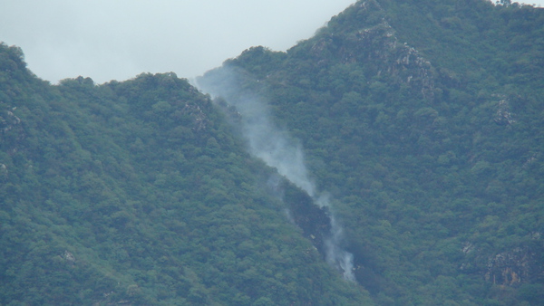
Дальше разьяснение ибо тут непонятка случилась - фото почти вертикальной стены с обломками - правильное. В инете где то засветились фото с обломками и люди ходят, на ровной местности - вот это из Пакистана.
З.Ы. А СМИ жгут.. Хоть бы Долю читали...
опечатка может где-то
минус нужно вводить , это южнее экватора
Это вроде фотка с места падения А321 в Пакистане (Air Blue 202) в 2010м...просто ракурс немного изменили...
ЗЫ странно, что до сих пор нет достоверных фоток с места падения
--- Добавлено ---
Это как? Посторонние в кабине?
Людей уже не вернуть....Но, пока, не пойму одного-зачем летать возле сопок или гор и еще не зная специфики рельефа???? Видим поворот-даем газу? Зачем??? Показать индонезийцам, как Суперджет может круто маневрировать?
Это неоправданный риск...
-Доктор, избавте меня от комплексов!
-А у вас какие?..
-Зенитно-ракетные...
Могли перед полетом снять , это промо-полеты , там много народу ходит смотреть , чего и как . Покупатели же.
Не изучен район полётов. + СМУ.
// CPU:i7-2600K/ MB: Gigabyte GA-Z77P-D3/ RAM: DDRIII-1600 8 GB PC12800 Kit (2 x 4 GB) Corsair XMS3 / 3 GB PCI-E Gigabyte GV-N78TOC-3GD/ LCD Philips 272C4QPJKAB/00 Black / Asus Xonar D2/PM / Saitek X-65F Pro/
Как командир корабля может не "знать" специфики рельефа, взглянуть перед вылетом было лениво? Не верю в это, слишком опытный пилот.
Как вообще можно разбить современный и исправный самолёт о гору? Даже не зная рельефа и т.п при наличии глонасов\жипиэсов-радаров-высотомеров, наземного сопровождения. Как!?
Судя по ЖЖ Доли (http://sergeydolya.livejournal.com/465758.html, смотрим фотографию номер 5, которая с комментарием "Летим мы на Суперджете 100. Кабина все время открыта. Пилоты - отличные мужики. Очень довольны самолетом") - всё-таки и в полёте тоже... Никого не хочу судить, просто, похоже, эти промо-полёты и впрямь несколько другие.
Too old to rock-n-roll, too young to die.
при стечении неблагоприятных обстоятельств - довольно просто. В жизни всегда есть место не только подвигу, но и ошибке - люди же, не роботы.
...
как это ни банально звучит , но нужно дождаться результатов расследования катастрофы
"...В кабине также есть ещё один прибор - барометрический высотомер; его основное назначение - внушать лётчику ложное чувство безопасности." (не помню откуда)
Жалко погибших, жалко самолёт, жалко тех, кому теперь придётся разгребать последствия.
"Каждый новый патч, как лакмусовая бумажка, выделяет из общей массы вирпилов самых криворуких и занудливых" (с) Afrikanda (ZAV)
Архив треков какого-то wannabe-Иксперта
Покупатели были на борту и погибли.
так радиовысотомер мог и показывать приличную высоту, а в последнюю секунду... посмотрите, какой склон горы крутой.
жалко ребят и пассажиров, светлая память...
ЗЫ. у нас уже начали писать в коментариях к обзору этой темы в прессе - не летайте самолетами построенными в России, уроды...
хорошо, что подобные опусы преса сама удаляет...
Еж - птица гордая, пока не пнешь - не полетит!
вопросы не риторические, а очень даже практические. Мне понятно как погибла Марина Раскова ГСС, у неё, отличного штурмана, кстати, из проборов были компас да высотомер, картой пользоваться не могла - видимость НОЛЬ, но в данном случае пилоты не были "слепыми".. сообщений о неисправностях\отказах оборудования не поступало
По ящику передали. В том районе было уже 7 авиакатастроф. Кроме того они снизились ниже официально разрешённой высоты полёта над заповедником.
Когда о монархе говорят, что он добр, значит, он ни к черту не годится. /Наполеон I/
 Ваши права

 Ответить с цитированием